

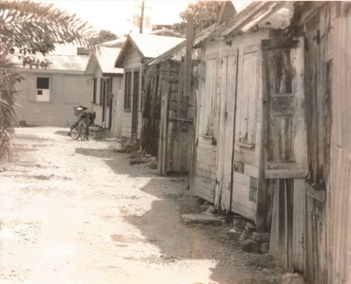
The Fibrey
The Fibrey was a vibrant community in lower St. John’s. It is known for the number of well-known Antiguans who were born there.
According to Emeric Simonkovich and Mitzi L. Buckley, authors of a book of photographs and text entitled Who We Were: Fibrey: The Rope Walk, the area was landfill, developed to meet the housing needs of the growing population of tradesmen and other workers who serviced the nearby docks. Simonkovich and Buckley believe that it derived its name from the fact that it served as a “rope walk,” an area where boats are built and where the hemp ropes used for hauling boats and cargo were woven, and that the landfill was done by “slaves and indentures.”
An examination of early maps of the area suggests that while there may have been landfill, there was little settlement until later. The 1799 Killian map shows that Ratcliff Street, Nevis Street, and Tanners Street (as they were named at the time) all ended at the water’s edge.
Compare this with a map from 1897, when the firm Charles E. Goad Ltd. created a series of detailed insurance maps of the city. Now you can see that the area between Tanner Street and Nevis Street had been filled in. (Note also the changed street names.) The Fibrey would have occupied Lot 21.
Because the Goad maps were done for insurance purposes, the detailed versions included every dwelling, by type (wood, brick, etc.). In 1897, the lot had very few buildings on it other than one attributed to Manuel Gomes:
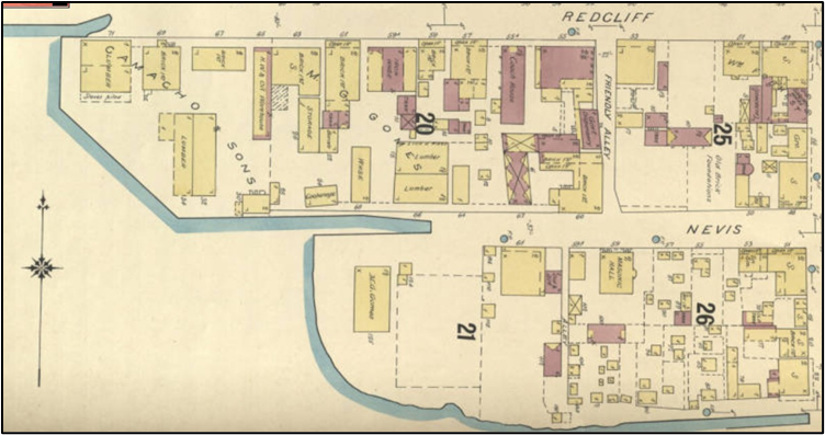
This suggests that the village itself did not develop until the early 1900s.
According to Simonkovich and Buckley, the land was originally owned by a man named Franklin Carlisle. Carlisle sold it to James Adolphus Nibbs Brown (J.A.N. Brown, Sr., also known as “Studiation Brown” for his support for education). It was across Nevis Street from Piggot’s Wharf, where many of the inhabitants worked.
Piggot’s Wharf was named for Jim Piggot, who bought it in 1918 from Robert William Dobson, the son of a Scotsman named W. R. Dobson who owned some small estates and shipped tamarind and animal skins from there. Jim Piggot bought other properties for family members, including the David Torry store for his brother Richard.
J.A.N. Brown, Sr. was an import-export merchant with a business at the bottom of Tanner Street. He passed the land on to his son Jim and Jim, who died in 1988, passed it on to his daughter—who then sold it to Edris Michael and George Ryan in partnership. Edris Clothing Store, on Tanner Street, marked the boundary. Although the Fibrey originally ended at the alley that marked the boundary between Lots 21 and 26 in the insurance map, it soon expanded up as far as Market Street, an area that the locals called “Top Fibrey.”
Whatever its origins, there is no doubt that the Fibrey was home to a vibrant community of hard-working men and women, from artisans to tradesmen to domestic workers, from blacksmiths to tanners to washerwomen, from rope-makers to sailors to boatmen, and Simonkovich and Buckley include many stories about the joys of growing up in the Fibrey, particular the fun the residents had as children swimming off the seawall.
By the late 1970s, as tourism developed, the government wanted to convert Piggot’s Wharf to a tourism destination—it was eventually renamed Redcliffe Quay. The Fibrey now began to be described in unflattering terms. For example, a World Bank economic mission to Antigua described it (along with Point) as “areas on the water front of St. John's that have deteriorated to slum conditions.” Those who lived in the Fibrey were deemed squatters (but without squatters’ rights) and the area was portrayed as a haven for crime. The fact that sanitation was minimal at best did not help, although in this regard it was no different from many other areas of the city. What was different was the location.
When the ABLP government decided to redevelop Heritage Quay and Redcliffe Quay in lower St. John’s in the 1980s, the Fibrey was considered an eyesore that had to be removed. The residents were offered the opportunity to resettle in Belmont and Bathlodge, but many did not want to move out into the country.
The drawing below, taken from The Development of Plans and Policies Toward the Preservation of the Historic Urban Core of St. John's, Antigua by Sharon Anne Thomas, published in 1991, shows the areas designated for development and removal:
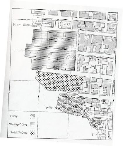
Edris and George Ryan had their own plans to develop the area and entered into protracted negotiations with the government about relocating the village. Finally, in 2002, the residents were offered land in Belmont and Bathlodge (UN United Nations Human Settlements Programme 2002), although it is not clear how many actually moved there. (Simonkovich and Buckley say they were moved to Bellview Estate, but Belmont and Bathlodge seem more likely, being closer to town.) The buildings in the Fibrey were demolished in 2004.
However, no development happened. Here is what the area looks like now.

This is a particularly cautionary tale because of the way an area that was home to hundreds of hard-working Antiguans was rebranded and then removed, all in the name of national development.